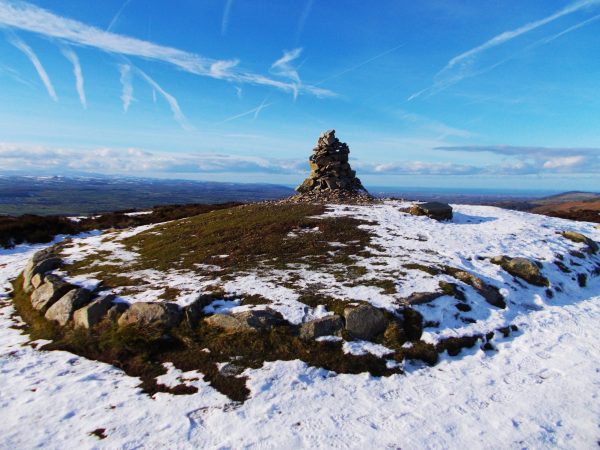
Penycloddiau
This our third walk from our guest blogger Julie Brominicks the author of The Edge of Cymru. They are all accessible by public transport and each one will have a simple map for you to follow. We have another 5 planned for you over the next few months, so look out for them on our social media channels. We want to inspire you explore our beautiful part of the world that little bit deeper.
If you lie in a hollow you can avoid the wind’s shriek but there’s no escaping the sky. What bold blue cupola is this? I can’t shake the feeling I’m in a snow globe. Whatever weather cajoles, caresses or chases you here, Penycloddiau – which at 440m, soars above the vale yet is uncrowded by nearby peaks – boasts uninhibited views and a sky that dominates.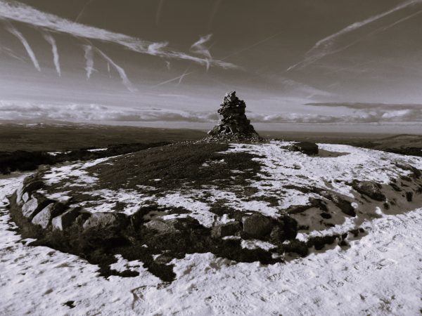
With a vantage point like this, little wonder that Bryniau Clwyd – the knobbly spine of hills running north to south down the east of Sir Ddinbych – was home in the Iron Age to four hill forts, plus Moel y Gaer in Bodfari and nearby Moel Hiraddug. You can visit them all in one hike but I’ve plumped for two; steam-pudding-shaped Moel Arthur and Penycloddiau, which at 18.9 hectares is one of the largest in Cymru.
From my snug hollow I am trying to imagine how it was in the Iron Age. To see the ramparts re-clad in timber, to repopulate the round houses whose footprints are just ghosts now, seen from the air in dry weather. To imagine the smell of animals, and smoke drifting through thatched roofs, the voices and clink of tools. Yes! I do hear voices. Four hikers from Staffordshire, who coax me out of the hollow to take their photo. “I don’t think they actually lived up here” says one, when I tell him what I’m up to. “It would have been a long way to go for firewood” says another.
The deforestation of these hills that began in the Bronze Age continued apace in the Iron Age, when the birch, oak, elm, lime, ash and alder woodland was cleared by these round-house dwellers in order to grow cereals and provide grazing. But live here they did. Dr Toby Driver (author of The Hill Forts of Iron Age Wales) tells me that “firewood may have been an issue but any rural community would have managed their woodland resources and coppiced what they needed for structural timber and firewood. And the valley isn’t far to go if you have oxen to pull up cartloads of wood.” Although it isn’t known, they may also have burned peat – peat bogs having supplanted the cleared woodland.
They must have loved the views. Today I see wind turbines off the North Cymru coast and Liverpool’s grey sprawl. Meanwhile the mountains of Eryri, roaring up in the west beyond a frosted Dyffryn Clwyd, would have been as mighty white then as now.
Bus
Bodfari is frequently served by buses between Dinbych and Yr Wyddgrug (Mold) – The 14 by P&O Lloyd and the 14D and 14M by Townlynx. The M&H and Arriva Cymru service number 76 between Dinbych and Llangwyfan also calls at Bodfari once a day.
For more information about public transport in Sir Ddinbych see https://www.denbighshire.gov.uk/en/parking-roads-and-travel/public-transport/public-transport.aspx
To plan your journey use https://www.traveline.cymru/
Don’t forget that a 1bws ticket for £6.50 gives you unlimited travel in North Cymru on all services.
Bodfari is well-placed for hill walks being crossed by Llwybr Clawdd Offa which gives you multiple route options. And if you have time to wait for your bus, you have St Stephen’s Church to visit, next to which The Dinorben Arms is open all day, seven days a week for food and drink and warmth.
Walk
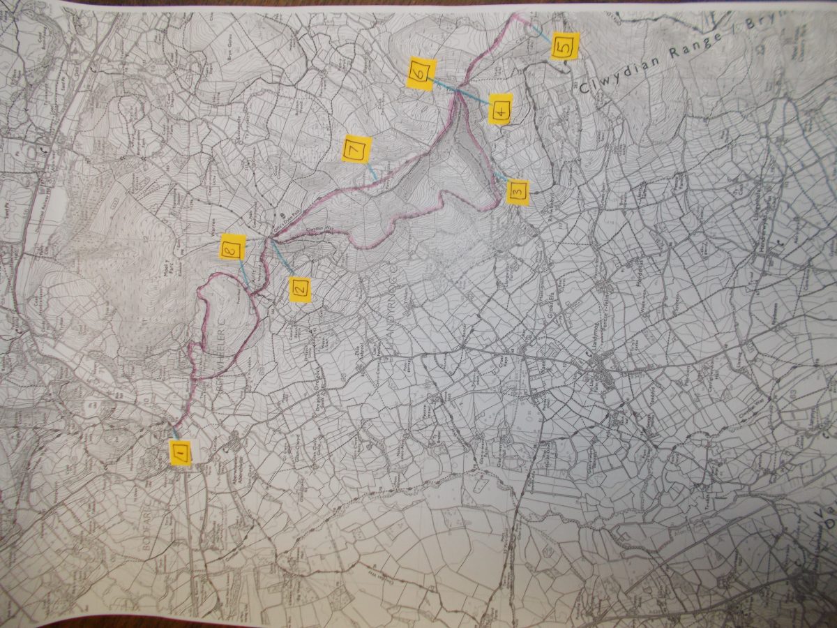
If winter conjures up crisp cold weather and clear skies, then take to the hills. Bryniau Clwyd is a hill range running south from Prestayn. This 11 mile loop, which combines part of Llwybr Clawdd Offa (Offa’s Dyke Path) with other routes, requires a good level of fitness and climbs to 440m. It follows way-marked paths but as always in hill country, take a map, know how to read it, and be prepared for bad weather. There is enough vigorous climbing on this walk to keep you warm – but expect a brutal breeze on the summits. On a clear day the views to Eryri, into England and across the north coast of Cymru are unrivalled.
- Alight at the Victoria Terrace bus stop for Llwybr Clawdd Offa (Offa’s Dyke Path.) Begin by following clearly marked Llwybr Clawdd Offa as it heads south. Follow it across Afon Chwiler, and hill fields, climbing steadily.
- At a junction of paths, take the lower of the hill paths (there is a still lower one if you prefer a steadier lane walk) following Taith Clwyd (The Clwydian Way) to Coed Llangwyfan.
- You have a choice of routes up through Coed Llangwyfan, a recovering conifer forest now a young mixed woodland.
- At the top carpark, re-join Llwybr Clawdd Offa. Follow the signs to Moel Arthur.
- At the stone sign, leave Llwybr Clawdd Offa for the summit path to Moel Arthur, one of several Iron Age hill forts. From here retrace your steps.
- Back at the carpark, take north-bound Llwybr Clawdd Offa keeping to the hill tops.
- The path takes you to the summit cairn of Penycloddiau, whose ramparts are still visible.
- Keep on Llwybr Clawdd Offa, but on reaching the path junction at Fron Haul you have the option of returning to Bodfari by circumnavigating the hill before rejoining your path back to Bodfari at Grove Hall Farm.